11 - Spatial & Temporal Data
What is the area of Northern Ireland?
SELECT ST_AREA(boundpath)*1406
    as "Area (km^2)" from political_unit JOIN boundary
    ON unitname = 'Northern Ireland'
    WHERE political_unit.unitcode = boundary.unitcode;
How close is the computed value to that reported in Wikipedia?
Wikipedia reports 13,843 km2. A finer grid would increase accuracy.
What is the eastern most city in Northern Ireland?
SELECT east.cityname FROM city east JOIN political_unit
    ON east.unitcode = political_unit.unitcode
    WHERE unitname = 'Northern Ireland'
    AND NOT EXISTS
    (SELECT * FROM city other WHERE ST_X(other.cityloc) > ST_X(east.cityloc));
Modify the example geometry database design to include
- Historic buildings in a city
- Walking paths in a city
- Use of the MULTIPOLYGON data type to indicate a political region’s boundary
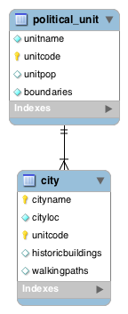
CREATE TABLE political_unit (
  unitname          VARCHAR(30),
  unitcode          CHAR(2),
  unitpop           DECIMAL(6,2),
  boundaries        MULTIPOLYGON NOT NULL,
      PRIMARY KEY (unitcode));
CREATE TABLE city (
cityname VARCHAR(30),
cityloc POINT NOT NULL,
unitcode CHAR(2),
historicbuildings MULTIPOINT NULL,
walkingpaths MULTILINESTRING NULL,
PRIMARY KEY (cityname, unitcode),
CONSTRAINT fk_city_polunit FOREIGN KEY(unitcode)
REFERENCES political_unit(unitcode));